Though I didn't have a ready answer for my cousin I had an idea where I might find the information. With any luck, FamilySearch's Trumbull County, Ohio, records might provide an answer. I found tax appraisement records from 1931 and earlier but because the images are not indexed I needed to search year by year, page by page. (For more about those records see previous post, County, Township, Range.)
Since this published collection of records ends in 1931, I needed to know what years my grandparents might have lived in the Ridge. Census records told me that W. C. Robert and Emma Meinzen lived in Warren in 1920 and in Mineral Ridge in 1930. With that information I guessed they may have moved sometime between those years and and that they may have purchased land before they moved. (It was common knowledge in the family that Gramma and Grampa owned the home they lived in on Furnace Street, but I had no idea when they may have purchased it.) I began a search of the 1931 records.
 |
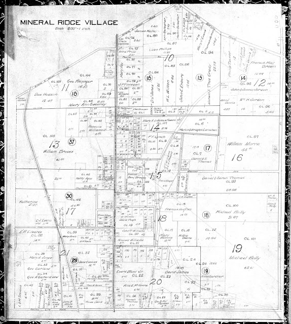
| 1910 Map of Mineral Ridge Village, Weathersfield Township, Trumbull County, Ohio |
Wm. C. R. & Emma Meinzen paid taxes on the following properties for the years noted.
1924-1931
- Out-Lot/Block/Division 109, identified as S. M. Pt. in the box "All or part of lot and name of street." I believe this was on Furnace Street.
- Lot 7, Leitch Tract/Plat, with Fr. Pt Orchard Ct. The lot size was 75.5 (along the street) x 63.52 feet deep.
- Lot 187, Leitch Tract/Plat, with 184.14 feet fronting Morris Street
The map above and the enlargement of a section below come from FamilySearch's Tax Appraisements Mineral Ridge, 1910, published 14 years earlier than when my grandparents first purchased property in Mineral Ridge. I've been unable to find a map closer to the dates of their purchases.
 |
| Section of 1910 map of Mineral Ridge, Ohio, showing Furnace and Morris Streets |
I see that Lot 109 is, indeed, on the north side of Furnace Street and is located where my grandparents' home was situated. And Lot 187 on the south side of Morris Street is near where Emma's father, Edward Jesse Bickerstaff, built a home. However, during the time I lived in the Ridge, decades after this map was published, there was no Maple Street running north from Furnace Street.
So my cousin's original question of whether Grampa owned the building where his barber shop was located will go unanswered until I have access to property records from 1931 through the late 1950s.
But she had two other questions which I was able to answer as a result of these tax records and the 1910 map of Mineral Ridge: When did Gramma and Grampa buy property in Mineral Ridge? and Where was the property on Furnace Street? I'm thrilled the tax records helped narrow down the years of purchase and that the map gave the answers to the question about location, for both the property on Furnace Street and Morris Street.
I have yet to find Orchard Court on the 1910 map because, I suspect, it wasn't there until after that map was created. And, of course, I'll want to learn whether Grampa owned the building where his barber shop was located.
This has been fun research, the results of which coincided with Amy Johnson Crow's 2019 version of 52 Ancestors' topic for this week: "Map It Out."
--Nancy.
Copyright ©2019, Nancy Messier. All Rights Reserved.
Do not copy or use any content from this blog without written permission from the owner.
.

No comments:
Post a Comment
I appreciate your comments and look forward to reading what you have to say. Thanks for stopping by.